
Begun in [month, year], the project is currently supporting 1,450 households to build resilience against recurrent flooding. The project is designed to provide pre-shock support to households anticipating the flooding with a given lead time of seven days, and post-shock support afterwards.
The IRC reviewed available data, held focus groups, and performed interviews with key stakeholders to identify the communities most affected by flooding caused by climate change. The assessment identified six communities, all of which experience flooding nearly ever year. These include Dulobwatiye, Ribadu, Dasin Hausa, Farangfarang, Rico, and Gembuesi. The data also showed that over the last 8 years, September has the highest frequency of flooding. Although, the extent of the flood varies from 2015 to 2019, the largest flood had a footprint covering about 5,249.14 hectares and was recorded in 2019. This represented a 34% increase compared to the previous years. You can see the data outlined by year below.

The focus groups with farmers also confirmed that farmers are moving upland to clear new virgin land because of the flooding, which further contributes to the negative impact of climate change.
Once this information was confirmed, the project team begun household registration. The project registered 2095 households (see table below) from the 6 flood-prone communities identified, using basic selection criteria such as:
- Farmers and pastoralists including men, women, youth
- Smallholder farmers that are into crop production, fishing and rearing of livestock
- Resident of the selected communities and not planning to relocate in the next year
- Households with people living with disabilities
- Female-headed households
- Elderly-headed household (60 years and above)
- Households that are most prone to climate shock (resident/farms along the flood plain)
- Household head of at least 18 years and above

The IRC established collaboration with the Nigeria Hydrological Service Agency (NiHSA), the Nigeria Meteorological Agency (NiMet) and the Upper Benue Basin Development Authority (UBBDA) to forecast and monitor hydrological and meteorological parameters such as water level, discharge, and rainfall. The collaboration focused on real-time monitoring of water levels, discharge and rainfall, data sharing, and early warning information dissemination to inform anticipatory action. These parameters were selected and monitored due to them being kay indicators associated with flooding.
Trigger readiness and activation thresholds for flooding response were also developed in collaboration with these three national stakeholders. The benchmarks for water level, discharge and the rainfall were set based on historical flooding records for flood readiness and activation of flood alert system. These parameters were monitored daily by stakeholders and the data were regularly shared with the IRC.
Water and discharge data were also collected by MiHSA, NiMet, and UBBDA and provided to the IRC weekly. Starting on June 29, the IRC received real-time data from the government agencies. The data was collected from gauge stations close to the communities of interest and were continuously updated each week. The data was then analyzed against the set thresholds for flood readiness and activation.


On July 22, 2022, the data from NiMet indicated that the rainfall would exceed the rainfall threshhold for the first week of August with a probability of 80%. It also indicated that there would be a risk of probable maximum rainfall that could cause flash flooding.

In addition to the three partner agencies, the Glofas platform was used to monitor accumulated precipitation. On July 20, 2022, the accumulated precipitation was predicted to be between 50mm and 75mm for the next 10 days with 80% to 90% probability of exceeding 50mm. This would exceed the threshold for the month of July.
Another platform used, Fanfar, monitored the water level at the Wurobokki gauge station. On July 20, 2022 the water discharge upstream at Wurobokki and downstream at Jimeta had increased from 318m3/sec on June 20th to 1185m3/sec on July 29th, and was 95m3/sec for the 10-day forecast. This made the severity a level 3, which is very high, and was likely to cause flooding downstream.

The project trained 24 early warning volunteers to provide disaster readiness and preparedness support, including dissemination of climate-smart adaptive behavior messaging to households.
On May 25, 2022, 24 volunteers (12 female and 12 male), 3 staff from the partner agencies, and 6 community leaders were trained on early warning systems. This included climate-smart agricultural practices using the early warning training guide that was developed by the IRC. The volunteers, with the support of the community leaders, and staff cascaded the training to households across the six the communities.
The community leaders were advised to give their communal authority to the early warning volunteers, to strengthen the dissemination of early warning messaging at the community level, to give credence to the information being disseminated. The volunteers organized community-based sensitization sessions and meetings, which helped cascade information to households.
In addition to this, information on climate-smart agricultural practices (such as planting early, use of drought resilient crops varieties, and harvesting early) were disseminated to households. The volunteers advised the clients about the August break and that they should look out for signs of drought.
On July 17, 2022, data indicated that the water level downstream had increased to 6.33m – exceeding the set threshold warning of 6.0m and nearing the peak flood threshold of 6.5m.
Following the onset of rains, the IRC distributed ID cards to clients and prepared to release the pre-shock cash assistance once an activation threshold had been reached. On July 21, 2022, the IRC communicated with NiHSA, NiMET and UBBDA to confirm the rise in water level and rainfall to release the pre-shock cash transfers to soon-to-be-affected households. The trigger decision was taken to give households ample lead time of at least 7 days to purchase goods and other items before the floods.
On July 27, 2022, the IRC provided pre-shock cash transfers to 725 households (53% male, 47% female) across six communities in anticipation of the impending flooding. At the time of the cash distribution, the flash flooding water had cut off the communities of Dulobatiye, Farang, and Rico completely. These communities where no longer accessible by vehicle or motor bike, and wooden boat was the only alternative means of transport.

Clients from these communities were mobilized by the early warning volunteers to come to Ribadu for the cash collection (as seen in the photo above).
After the cash disbursement, the IRC continued to monitor rainfall, water levels and water discharge, and the provision of early warning information. For example, on July 27, 2022, the water level at the Jimeta gauge station increased to 4.71m with a 3-day moving average of 4.8m. This was up from 2.8m on June 29, 2022 and exceeded the warning threshold of 4.5m.
Another example was on July 25, 2022, the water level at the Wurobokki gauge station increased to 5.71m with a 3-day moving average of 5.5m, up from 4.31m on June 29, 2022. This exceeded the threshold between 4.0 -5m and 5.5m (see table). Although, the water level had dropped on August 2, it increased again to 5.96m on August 21.
Project Impact
In the current period, the project established a system for anticipatory action that supported 725 households with pre-shock cash transfers and early warning disaster risk reduction messaging, while another 725 households will receive post-cash transfers and climate smart adaptive behavioral messaging to support households to recover and rebuild resilience against recurrent climate shocks.
Some of the feedback from the households indicates that they were able to buy food that lasted them for the period of the flooding, farm tools, fertilizer and bicycles that helped them recover from the flooding and re-establish their livelihoods, amongst other purchases.
According to OCHA report released on the 12th of August 2022, over 50 people have died with many displaced as flood ravages parts of Jigawa State-Nigeria.
There is need to scale up the implementation of this anticipatory program to other communities to support smallholder farmers build resilience against climate shocks. The government stakeholders indicate that flooding and drought are now becoming widespread due to the climate change phenomenon.
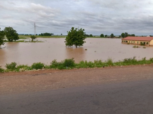
For example, some areas of Adamawa State, where the IRC’s Climate Resiliency project has been implemented have experienced serious flooding this year that displaced many rural households. In the Numan community, the flooding has forced schools to close due to submerging of classrooms because of flooding (see picture below).
This program can strengthen anticipatory response coordination, and support households to build resilience, and take action to reduce the impact of the flooding. In addition, appropriate technologies for adaptation and mitigation should be deployed at all levels. We need strengthen capacity and infrastructure for mainstreaming climate change.
Next steps
Google project
- Provide post cash shock transfer
- Conduct evaluation
- Disseminate project results and findings
Post Google
Scaling up anticipatory action in areas affected by climate shocks
The Anticipatory project can be scaled-up to other communities that has been experiencing the issue of climate sock in Adamawa state to build resilience among vulnerable households.
Evidence from the current project has shown that when households have access to timely information and resources to prepare against flood shock, they would build resilience against climate shock. The scale up will focus on:
- Scaling up the early warning system model to other communities to increase access to climate and weather-related information.
- Scale up the adoption of climate- smart agriculture and adaptive behaviors to other communities including irrigation crop production and climate smart agricultural practices.
- Strengthening the anticipatory action coordination and sharing of information on flooding and drought forecasting for timely action
- Diversification of livelihood through training and provision of fishing gear, and irrigation pumps for farmers to engage in more of fishing in the wet season and irrigation cultivation in the dry season.
- Provision of cash transfers to households affected by the flooding to recover and rebuild their livelihoods.
- Support farmers with postharvest management skills such as trainings and provision of improved grain storage bags (PICS) bags to farmers to support with storage of farm produce that can be stored for a long period of time.
Currently, the IRC has received funding for a year period from Hilton Foundation to provide disaster risk reduction support to small holder farmers in some of these communities impacted by climate related disasters in these locations.
Challenges
- Climate -induced recurrent flooding and drought are now widespread, and more communities are in needs of early warning systems and smart weather livelihoods strategies.
- Funding
- Limited access to data and lack of standardize thresholds for flooding trigger activation for national wide response.
- False alarm
Opportunities
- Collaboration/partnership with relevant stakeholder
- Standardization of trigger threshold and activation for national wide use.
- Scale the use of Anticipatory action in the states most impacted by the decade-long insurgency i.e. Borno, Adamawa and Yobe (BAY) states of Nigeria
- Establish weather - smart communities in the BAY states of Nigeria
- Government ownership of the process for sustainability and replication to other communities
- Funding limitations